 |
About Swiftcurrent Pass Trail
- Trail Highlights – Crystalline alpine lakes, lush meadows strewn with wildflowers, gorgeous views of the surrounding snowcapped peaks and plentiful wildlife.
- Roundtrip Length – 13.4 miles
- Elevation Gain – 2,500 feet
- Peak Elevation – 6,770 feet
- Parking Lot — Yes
- Difficulty – Varies from easy at the beginning to strenuous at the final leg
- Region -` Many Glacier
- Availability of Water — Yes
Located in the spectacular Many Glacier portion of the park, Swiftcurrent Pass Trail can be divided into two sections, ranging from easy to strenuous. This makes it a great hike for a variety of ages and abilities, depending on which section of the trail you choose to explore.
If you only visit one portion of Glacier National Park, this is the area to choose, as it’s the most accessible and affords the biggest rewards in terms of mind-blowing scenery and opportunities for wildlife viewing.
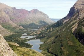
The trailhead is located at the end of Many Glacier Road near the campground and concessions area. The first part of the trail is the easy part because it’s relatively flat as you hike the four miles to Bullhead Lake, with level terrain interspersed with gradual inclines as you make your way past Fishercap Lake and Red Rock Lake.
Along the trail, you’ll be rewarded with spectacular panoramic views of Mount Wilbur, Mount Grinnell, Swiftcurrent Mountain and the Continental Divide.
The first leg of the trail is an easy .8 miles to Fishercap Lake. The lake itself is a short 200 yard jaunt off the trail, well worth the extra legwork to take in glorious views of the craggy mountain peaks reflected in the shimmering water.
After taking a break at Fishercap, you’ll proceed along the trail for another 1.8 miles to Red Rock Falls. It’s a small waterfall on Swiftcurrent Creek, and another nice resting place to take a short break.
Proceed another .2 miles along the trail and you’ll find yourself at Red Rock Lake, a glittering jewel nestled into a narrow valley with the surrounding peaks towering along its shores.
It’s an awesome sight, with the snowcaps reflected in the lake and a great spot to hang out for awhile.
If you’re an angler, be sure to bring your gear, because this is a primo spot to bag yourself a couple of the beautiful trout that call the lake home. It’s also a prime area for spotting moose who like to congregate in the area (learn how to safely watch moose so you can avoid a moose attack).
 |
|
So Many Awesome Views At Swiftcurrent Pass |
At this point, the terrain becomes less forested, opening up into lush, wide meadows strewn with wildflowers in summer. Due to the severe climate and harsh winter winds, the trees in this area are somewhat stunted and misshapen.
Proceed along the trail for 1.2 miles to Bullhead Lake, which is actually two lakes bridged by Swiftcurrent Creek.
The upper lake is the more spectacular of the two, surrounded as it is by the towering peaks of Swiftcurrent Mountain, the Continental Divide and Mount Wilbur.
The Final Leg of Swiftcurrent Pass
The final leg of the trail beyond Bullhead Lake is where the hike gets strenuous, ascending three miles and 1500 feet in elevation as it makes its way up to the Continental Divide to the top of Swiftcurrent Pass.
It’s a steep, arduous trek, but well worth it, rewarding hikers with a breathtaking, panoramic view of some of the most gorgeous scenery known to man.
From here, if you’ve got the energy and stamina, you can continue up to the trail to the Lookout Tower.
It’s another strenuous, steep trek, gaining 1600 feet in elevation in the 1.4 miles it takes to get to the top, but again, the payoff is worth it for the mind-blowing vistas from the top.
If you’re not up for the hike up to the Lookout Tower, you can proceed down from Swiftcurrent Pass to the Granite Park Chalet another .9 miles along the trail. The Chalet is a rustic inn that was built by the Great Northern Railway in 1915. It’s open during the summer months, with rooms available by reservation only. There is no restaurant facility at the inn.
From the chalet, you can return via the Loop Trail to Going to the Sun Road or the Highline Trail to Logan Pass.
Additional Glacier National Park Hiking Info
Check out other Glacier National Park hiking trails, or head back to the hikes in the Many Glacier area.
Return home to
Glacier National Park Travel Guide


Speak Your Mind