 |
About Dawson Lake Trail
- Trail Highlights — Lake views, mountain vistas, valley panoramas, waterfalls, and possible moose
- Roundtrip Length — 18.8 miles
- Elevation Gain — 2,935 feet
- Peak Elevation — 7,600 feet
- Parking Lot — Yes
- Difficulty — Strenuous
- Region — Two Medicine
- Availability of Water — Yes
The Two Medicine region of Glacier is an absolute paradise. The mountains are majestic, the weather is often perfect, the lakes are pristine, the wildlife is everywhere, the wildflowers grow in abundance, and the spirit of nature just seems full and bright.
One of the most rewarding treks in the area is the Dawson-Pitamakan Trail Loop.
This is a long one, and it’s a fairly difficult one, too, but you’re given a treat every step of the way in the form of unbelievable and unforgettable vistas.
As this trek is a loop, you have your choice of which direction you want to go first. You can head off to Pitamakan first from the North Shore parking lot, or you can take the ferry across Two Medicine Lake (shaving a good 4-5 miles off your trip) and head up towards Dawson Pass first.
I personally enjoy the latter more than the former, so let’s take the shuttle across the lake and begin our journey on the South Shore.
The trailhead is a bog-like area that can be a prime spot for catching a photo of a moose. It doesn’t happen very often, but if one of those big guys showed up while you were starting your hike, it wouldn’t be the first time (learn how to safely observe moose in the wild so you won’t be the victim of a moose attack).
Continue on the South Shore trail, going straight when you get to the junction with Two Medicine Pass Trail. This first portion of the hike is pretty level and fairly easy to walk. It’s also stocked full of awesome and quick side adventures to scenic view points and waterfalls, like Aster Falls.
Eventually, you’ll connect with the Dawson Pass Trail, which you’ll follow to the west. Just beyond the junction is a fantastic photo op of Pumpelly Pillar, a breath-taking mountain mass that juts 7,600 feet into the sky. You’ll see this big guy a few times along the hike, but this is probably the most pic-worthy view of PP you’ll see. So, take the time to take it in!
This is the point where the trail goes from easy to moderate, and then beyond.
While the trail has been pretty level up to this point, now it’s going to take a turn for the sky. Just a couple of miles from the South Shore trailhead you’ll run into some switchbacks that take you up, up, up to the No Name Lake Trail junction. I definitely recommend you make this side trip (it’s only 0.1 miles!) to see this beautiful body of water. There’s also a 3-site campground here for some extended relaxation.
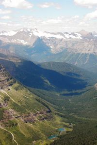 |
At just under the 5-mile mark, you finally reach Dawson Pass, which sits on the saddle formed between Mt. Helen and Flinsch Peak. This here is the Continental Divide, and at an elevation of 7,600 feet, it’s also a place where some amazingly gorgeous pictures can be taken.
One thing you need to be prepared for–both for Dawson and Pitamakan Passes–is the wind.
Glacier National Park weather can change in an instant and up at this elevation, with such wide-open surroundings, you’re going to be hit with wind of bone-rattling intensity. So make sure you’ve got the appropriate hiking gear and balance before taking a peek over the edge!
Heading west from Dawson Pass, the Loop Trail takes you ever onwards to Pitamakan Pass, another astoundingly beautiful location with astoundingly beautiful views. Take your time up here and soak in Mother Nature’s supreme artistry–it’s something you won’t soon forget.
The back-end of the Loop drops you about 900 feet over the next two miles to Oldman Lake, which features four individual camp sites and some more great photo ops of its pristine waters.
The descent from here is pretty fair–about 1,500 feet over the course of six-or-so miles–as there’s nothing super challenging about it. The worst of the trek came between No Name and Dawson pass, where you’re climbing 1,650 feet in less than two miles. Compared to that, the rest of this hike is easy-peasy and steady-as-she-goes.
Because of the steep climb before Dawson, this trek isn’t recommended for inexperienced or out-of-shape hikers. The back-end might be a breeze, but the ascent will probably be too difficult to finish in a timely fashion. But if you’ve got the grit, the muscle, the stamina, and the spirit of adventure, the Dawson-Pitamakan Loop Trail is an absolute can’t-miss journey.
Additional Glacier National Park Hiking Info
Check out other Glacier National Park hiking trails, or head back to the hikes in the Two Medicine.
Return home to
Glacier National Park Travel Guide


The trail looks just phenomenal. I’m heading out to Montana in mid-June. Will this be too early to give it a shot? Thanks for your advice!
Dawson-Pitamakan is unreal! Unfortunately, mid-June is definitely too early for the whole trail. It will be very snow covered still.
Check in with the Ranger Station when there just to clarify though. And be sure to send us some photos!